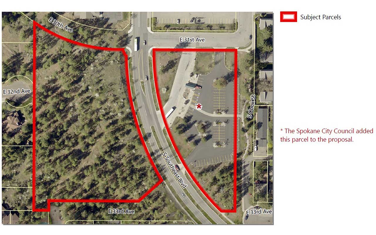
31st Avenue Comprehensive Plan Amendment

This proposal was adopted by City Council on November 21, 2022.
Application Number: Z21-282COMP
Address:
- 2402 E. 31st Ave. (private application)
- 2502 E. 31st Ave. (City proposal)
Parcels:
- 35331.0017 (private application)
- 35331.0014 (City proposal)
Size:
- 3.81 acres (approximate, private application)
- 2.23 acres (approximate, City proposal)
Location: West and East of S Southeast Blvd, S of E 31st Ave
Neighborhoods: Lincoln Heights
Proposed Amendments: Land Use Plan Map Designation and Zoning Designation
Land Use Change: "Residential 4-10" to "Residential 15-30" or "Centers & Corridors Transition (CC-Transition)" *
Zoning Change: "Residential Single Family" to "Residential Multifamily" or "Centers & Corridors Transition (CC-Transition)" *
* At their July 13 workshop, the Plan Commission directed Staff to provide additional information on a possible Centers & Corridors Transition (CC-Transition) land use designation and Centers & Corridors Type 4 (CC-4 DC) zoning. This is in addition to the originally proposed Residential 4-10 land use and RMF zone. The Plan Commission is expected to consider both options and we anticipate their vote during their hearing to select which they feel is more appropriate for the subject properties.
Applicant
Liam J. Taylor, Storhaug Engineering and City of Spokane
Description
A proposed amendment to Chapter 3, Map LU-1, Land Use Plan Map and a concurrent amendment to the City of Spokane Official Zoning Map. This project is a private application for a 2020/2021 Comprehensive Plan Land Use Amendment.
Related Documents
- Signed Ordinance (PDF 7.0 MB)
- Findings and Conclusions (PDF 228 KB)
- Threshold Application (PDF 3.4 MB)
- Land Use Maps (PDF 2.1 MB)
- Zoning Maps (PDF 2.0 MB)
- SEPA (PDF 490 KB)
- Request for Comments (PDF 3.3 MB)
- Request for Public Comments (PDF 2.6 MB)
- Staff Report (PDF 9.0 MB)
- Determination of Non-Significance (DNS) (PDF 216 KB)
- Hearing/SEPA Notice (PDF 2.6 MB)
- Additional Public Comments (PDF 1.1 MB)
- Z22-282COMP Proposed Bike Network Map Amendment (PDF 1.6 MB)
Contact Information
City of Spokane
Department of Planning Services
808 W. Spokane Falls Blvd.
Spokane, WA 99201
509.625.6500
KayCee Downey, AICP
Assistant Planner II
509.625.6194
kdowney@spokanecity.org
Kevin Freibott
Assistant Planner II
509.625.6184
kfreibott@spokanecity.org
Tirrell Black
Principal Planner
509.625.6185
tblack@spokanecity.org
