Hillyard Subarea Plan


Project Description
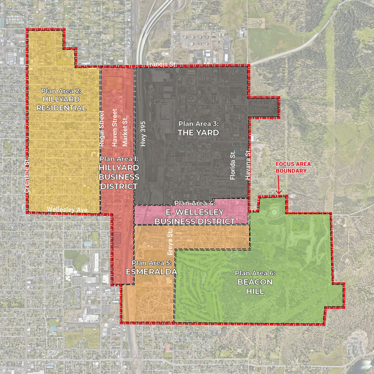
The Hillyard Subarea Plan outlines a comprehensive vision for revitalizing Spokane’s Hillyard neighborhood, focusing on infrastructure improvements, economic development, housing needs, and land use strategies. The 1,740-acre Focus Area is divided into six distinct Plan Areas (Hillyard Business District, Hillyard Residential, The Yard, East Wellesley Business District, Esmeralda, and Beacon Hill) and addresses long-standing challenges such as environmental contamination, infrastructure deficiencies, underutilized properties, and limited economic opportunity. The plan integrates community feedback, identifies catalyst redevelopment sites, proposes land use changes, and outlines key improvements in transportation, utilities, parks, and funding strategies. It aims to guide both near- and long-term investments while supporting growth in this historically underinvested area.
This project was created from opportunities presented by the combination of American Rescue Plan Act (ARPA) funds, an EPA Brownfields Grant, an Integrated Planning Grant from the Washington State Department of Ecology, and a direct investment from the Northeast Public Development Authority (NEPDA). A significant amount of past planning work has already occurred in Northeast Spokane and the project recognizes this and aims to build from those efforts to create a plan that will lead to tangible results in the short and midterm by providing comprehensive and realistic action and funding strategies.
We are pleased to announce that the final document has been completed and is ready to be reviewed and begin the process of formal recognition by the Plan Commission and City Council.
Final Document
Supporting Technical Documents
The following are supporting technical documents which inform the goals and policies that are listed within the Hillyard Subarea Plan Document.
Hillyard Subarea Plan: Market Analysis
The purpose of conducting a market analysis is to learn about trends in population, housing, employment, and real estate within the Hillyard Focus Area. This information is then used to project future population and job growth in order to estimate the future demand for residential, commercial, and industrial land uses.
- Hillyard Subarea Plan: Market Analysis (PDF 2.0 MB)
Hillyard Subarea Plan: Public Financing Strategy
This report summarizes the analysis and recommendations of Economic & Planning Systems (EPS) regarding funding and financing strategies for the Hillyard/ Northeast Spokane Subarea Plan (Plan).
- Hillyard Subarea Plan: Public Financing Strategy (PDF 2,419 KB)
Urban Framework Plan
The Urban Framework Plan (UFP) shows aspirational changes in the Hillyard Focus Area related to land use, infrastructure, and urban design. The goal is to leverage investment to enhance the neighborhood. Additionally, the UFP identifies 53 catalyst sites. These sites have been determined to have great potential for reuse, development or additional property investment.
- Urban Framework Plan (PDF 2.5 MB)
Catalyst Sites – Conceptual Redevelopment Scenarios
The Redevelopment Scenarios show potential redevelopment and new development in the Hillyard Business District and along the East Wellesley Corridor District.
- Catalyst Sites – Conceptual Redevelopment Scenarios (PDF 1.1 MB)
Proposed Land Use Updates
The goals of the proposed land use changes are to diversify and intensify the types of uses allowed throughout the Subarea Plan Focus Area. The proposed changes located in “The Yard” would stay true to the area’s industrial roots while allowing a greater range of uses around the Wellesley Corridor. The proposed land use changes along Valley Springs Road would allow for a denser and more amenity-rich neighborhood.
- Proposed Land Use Updates (PDF 490 KB)
Plan Areas

The Subarea Plan approaches reuse and revitalization planning as a series of six “Plan Areas” with the goal to recognize and address the unique land use and infrastructure needs for these geographic areas within the larger Focus Area.
The Subarea Plan Area encompasses the parcels and public rights-of-way within the Hillyard neighborhood (including its business district), the east Hillyard industrial area (also referred to as “the Yard”), portions of the east and west residential Hillyard Neighborhood and the western slopes of Beacon Hill. The approximate 1,740-acre Plan Area is generally bounded by Crestline Street to the west, East Wellesley Avenue/Garnet Avenue to the South, South Havana Street/North Fancher Beacon Lane to the east, and East Francis Avenue to the north.
Key Components
The Subarea Plan project includes the following key components:
- Existing Conditions Analysis: A review of the existing conditions focusing on area character, housing, transportation/mobility networks, utility and drainage facilities, market conditions, and the current zoning/regulatory framework.
- Past Plans and Technical Studies: The subarea planning process will review and build upon past planning documents and technical studies. Notably:
- 2010 Greater Hillyard North-East Planning Alliance neighborhood plan (PDF 1.1 MB) which focused on area improvements, safety enhancements, business development, educational opportunities, and City coordination.
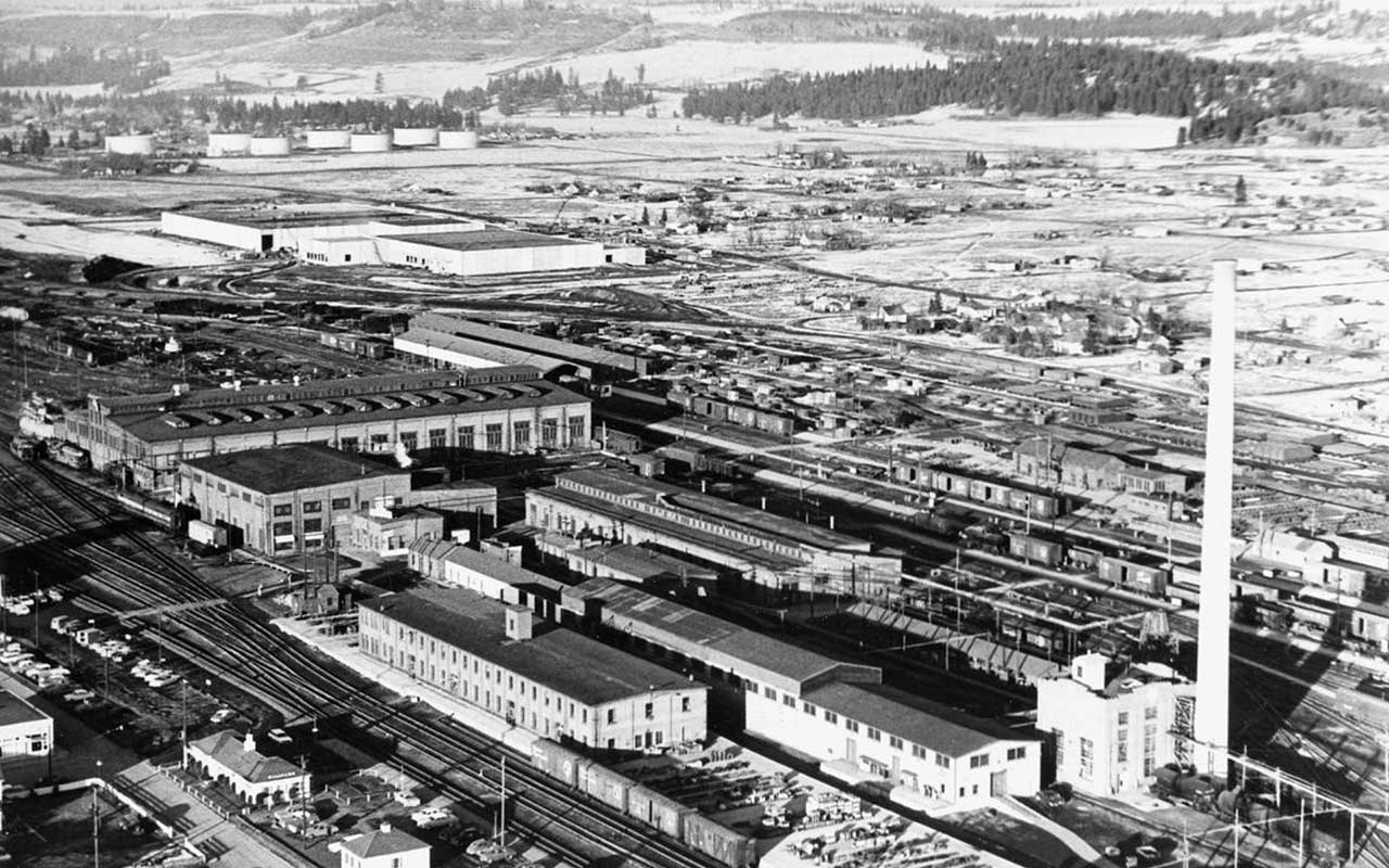
- 2017 The Yard Master Plan (PDF 11.5 MB) which identified transportation, utility, and drainage deficiencies.
- 2020 Funding Strategies Plan for the Yard (PDF 4.1 MB), complete by Stantec, which matched potential state, federal and philanthropic fundings sources to capital projects identified in the 2017 Master Plan.
- Community Engagement: The engagement plan will include community surveys, stakeholder group interviews, community workshops, and a project steering committee.
- Opportunity Site Inventory: An inventory of each parcel in the Plan Area with a priority on legacy industrial, commercial and multifamily properties to document property conditions and to identify sites for potential development.
- Catalyst Site/Area Planning: Detailed conceptual planning for one redevelopment site and two business district corridors to plan for future urban infill projects, streetscape enhancements, amenities, and other elements that would support area revitalization.
- Urban Framework Plan/Revitalization Strategies: This plan will illustrate potential land use designations, redevelopment sites, streetscape/mobility projects, and other community amenities. An analysis of the long-range development potential on designated redevelopment sites in terms of land uses and development scale. A list of revitalization strategies focused on mobility, supportive infrastructure, amenities, marketing/branding, and management.
- Fundings Strategies: An in-depth analysis of financing sources and structures the City/NEPDA can employ to leverage future investment, grants and local monies to fund capital improvement projects.
- Subarea Plan Document: A final planning document that details the planning process, existing conditions analysis, planning ideas, and recommendations for implementation.
- Project Approval / State Environmental Policy Act Checklist Support: Consultant support for the City/NEPDA to advance the Subarea Plan through the local adoption process.
Email Updates
Project Activities
- Oct. 27 & Nov. 3, 2025: City Council Adoption
- Sept. 10, 2025: Plan Commission Public Hearing, City Hall, 4 p.m.
- Sept. 8, 2025: City Council Urban Experience Committee, City Hall, 12 p.m.
- Aug. 14, 2025: Presentation to the Bemiss, Hillyard, Logan, Whitman Joint Neighborhood Council, Northeast Community Center, 6 p.m.
- Aug. 13, 2025: Plan Commission Workshop, City Hall, 2 p.m.
- Aug. 8, 2025: NEPDA Board Meeting Presentation
- March 27, 2024: Plan Commission Hillyard Retreat and Presentation (PDF 5.2 MB)
- March 14, 2024: Steering Committee Meeting
- January 2024: Speaking with Rogers High School Students
- Dec. 15, 2023: Public Engagement
- Speaking with Rogers High School Students about the Hillyard Subarea Plan
- Nov. 29, 2023: 2nd Steering Committee Meeting
- Sept. 21, 2023: 1st Steering Committee Meeting
- Sept. 2023: Public Engagement
- Wednesday, Sept. 20: Discovery Walking Tour at 4 p.m. and Community Workshop 6 – 8 p.m.
View Flyer (PDF 509 KB) and Walking Tour Map (PDF 408 KB)
- Wednesday, Sept. 20: Discovery Walking Tour at 4 p.m. and Community Workshop 6 – 8 p.m.
- Aug. 5, 2023: City Staff at the Hillyard Festival
- View Festival Photos (PDF 13.8 MB)
- June 2023: Consultant performs existing conditions analysis including site visits
- May 2023: Project kickoff
- Plan Commission Presentation – June 28, 2023 (PDF 2.7 MB)
Plan Drafts
- Subarea Plan – August 29, 2025 (PDF 11.1 MB)
- Plan Appendices – August 27, 2025 (PDF 15.9 MB)
- Subarea Plan – July 24, 2025 (PDF 8.6 MB)
Additional Information and Resources
- Northeast Brownfields Project
- GHNEPA Neighborhood Plan (2010) (PDF 1.1 MB)
- The Yard Redevelopment Master Plan (2017) (PDF 11.5 MB)
- NEPDA Funding Strategy Plan (2020) (PDF 4.1 MB)
Project Updates
Be the first to get project udpates.
Related Information
- Hillyard Subarea Plan Update – Oct. 20, 2025
- What We’ve Been Doing – Dec. 18, 2024
- Documents to Inform Policy Recommendations in Final Plan – July 23, 2024
- Hillyard Tour Offers Firsthand Look for Commission, Staff, Council – Apr. 8, 2024
- Speaking with Rogers High School Students – Jan. 31, 2024
Contact Information
Tim Thompson, AICP
Principal Planner
City of Spokane Planning & Economic Development
509.625.6893
hillyardplan@spokanecity.org
Jesse Bank
Executive Director
Northeast Public Development Authority
509.795.0290
jesse.bank@northeastpda.com
Jackie Churchill
Planner I
City of Spokane Planning & Economic Development
509.625.6986
hillyardplan@spokanecity.org
Ryan Shea
Planner II
City of Spokane Planning & Economic Development
509.625.6087
hillyardplan@spokanecity.org
